The first map of the “known world” appeared during the 6th century BC. Created by the ancient Greek thinker Anaximander, the map remained rudimentary and simple, and only portrayed known landscapes and territories.
Anaximander’s thoughts, however, led to the pre-Socratic Greek philosophy, geometry, cosmology, and politics. Master at the school of Miletus, Greece, Anaximander was the first philosopher to write his studies and rational thoughts on paper. Although most of his works have been damaged by the passing of time, several fragments of his books remain, until this day, unchanged.
It is through the analysis and description of his works that archeologists have understood the philosopher’s rational thinking. Not only did he lay the basis of logic to solve problems, but he also showed a particular interest in describing different aspects of the world and the universe. According to him, the world and the universe had to be understood as concepts ruled by laws, like societies.
His first works portray attempts of understanding the relation of planets among one another and in regard to the sun; and his willingness of apprehending the world led him to draw the first geographical map ever drawn by mankind. The map was still based on a flat Earth paradigm.
After Anaximander set the basis of maps and of the charting process, several other Greek philosophers tried to improve the pre-existing maps. Herodotus, Ptolemy and Eratosthenes have enhanced the quality of already existing charts and developed Greek geography. A few years later, Aristotle was credited with proving the sphericity of the Earth; and the first map of a spherical earth appeared during the Hellenistic period.
Maps continued to change as time passed, always improved, modified, and ameliorated. In 1321, the Italian geographer Pietro Vesconte charted the Mediterranean and the Black Sea accurately. He also progressively added more accurate descriptions of European coastlines and seas.
In 1492, Christopher Colombus first set foot on America; however, a hundred miles from the North-American territory, a brand-new spherical map was revealed to the public eye: the first ever constructed globe. Produced by Martin Behaim, the globe was called the “Erdapfel” (from German meaning Earth apple) and is considered as the oldest surviving terrestrial globe. As Christopher Colombus had not yet returned from the Americas, the Unknown territories are not included and the Pacific Ocean reaches out to the Atlantic ocean.
It is only in the 1500s that the Americas appeared on maps. A Spanish cartographer and explorer, Juan de la Cosa, charted the first map which included American territories. Today exhibited at the Museo Naval in Madrid, reproductions are currently visible to understand the evolution of our world.
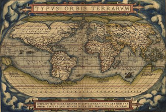
Maps and charts have continued to be redrawn and published as years passed; in 1520, the Pietro Coppo Map included the “Dragon’s tail”, in 1570 the Theatrum Orbis Terrarum was drawn by Abraham Ortelius. Considered as the ancestor of today’s atlases, it consisted of a collection of maps and texts bound to form a book.
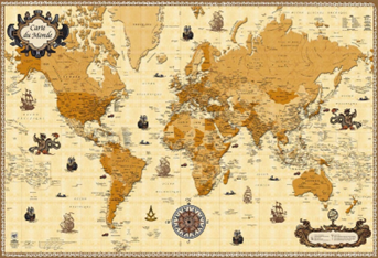
Since the 18th century, maps have undergone less and less modifications as the newest technologies have permitted the complete and accurate charting of the world. However, as time passes, we may realize that we may have overlooked some details…
Laurie Le Roux
